

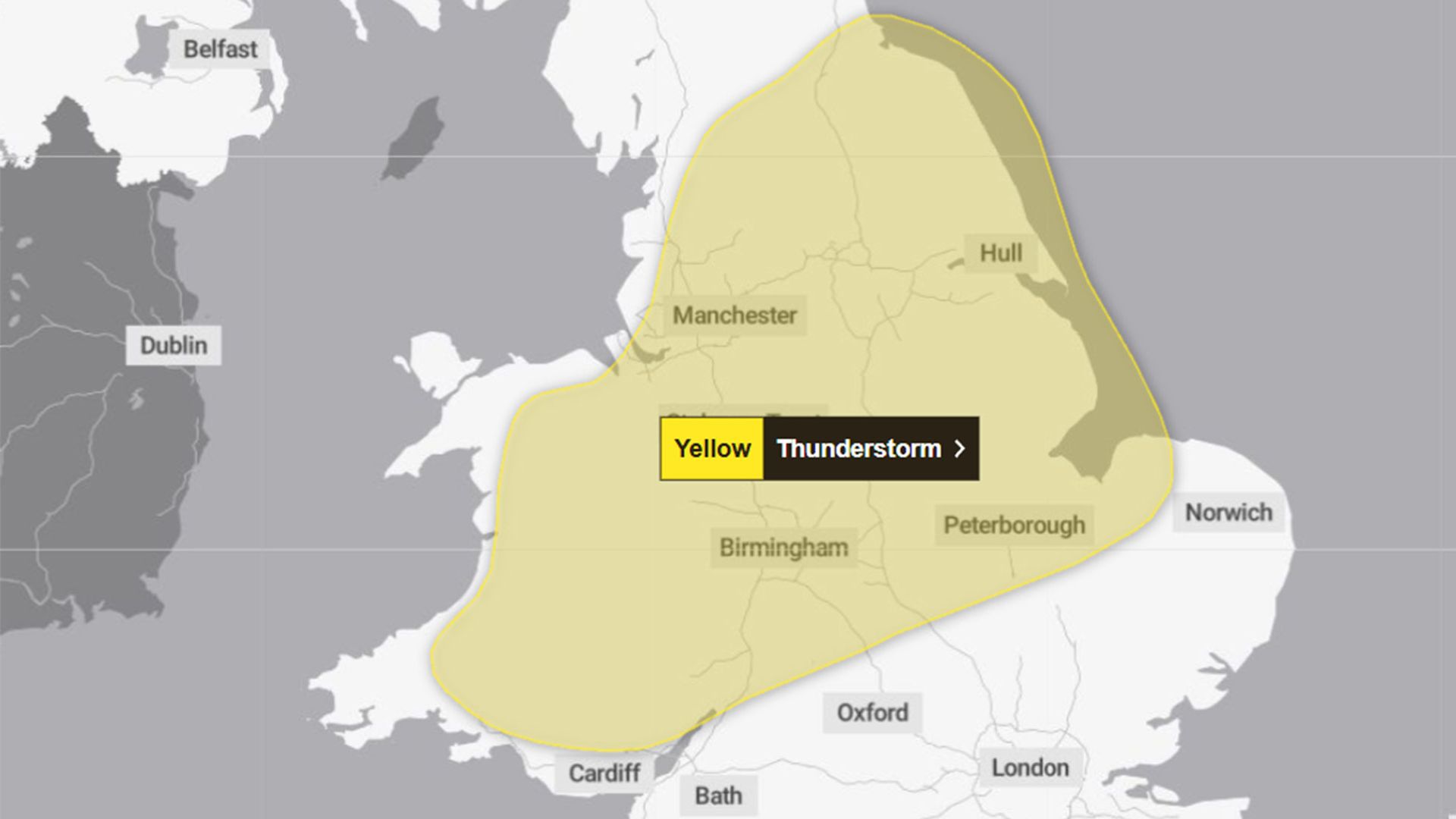
The Met Office has issued a yellow weather warning for large areas of England and Wales, forecasting heavy showers and thunderstorms that could trigger flooding and significant travel disruption on Friday. Residents and commuters are urged to prepare for potentially hazardous conditions as the storm system moves across the region.
What the Yellow Warning Means
The Met Office’s yellow warning signals that severe weather could cause some damage and disruption, though it is not as critical as amber or red warnings. This alert covers a wide swath of territory in both England and Wales, highlighting the likelihood of intense downpours accompanied by thunder and lightning. These conditions raise the risk of localized flooding, especially in urban and low-lying areas prone to water accumulation.
Heavy rain combined with thunderstorms can overwhelm drainage systems, leading to water pooling on roads and pavements. This increases the danger for drivers and pedestrians alike, as well as the possibility of delays or cancellations for public transport services. The yellow warning advises people to stay informed about changing weather conditions and to plan their journeys accordingly.
Potential Impacts on Travel and Daily Life
Friday’s weather is expected to disrupt travel networks across the affected regions. Flooded roads may become impassable, forcing drivers to take longer routes or face delays. Public transport, including bus and rail services, could experience cancellations or altered schedules due to waterlogged tracks or road closures.
Commuters should anticipate slower journey times and consider alternative routes or modes of transport where possible. Emergency services might also face increased demand responding to weather-related incidents such as traffic collisions, flooded properties, or fallen trees caused by storm winds.
In addition to travel challenges, the thunderstorms pose risks to outdoor events and activities. Organisers may need to postpone or cancel gatherings to ensure public safety during periods of intense lightning and heavy rainfall.
Why This Weather Warning Matters
Storms with heavy rainfall and thunder can have far-reaching effects beyond just temporary inconvenience. Flooding can cause property damage, disrupt businesses, and create hazardous conditions for vulnerable populations. Early warnings like the Met Office’s yellow alert play a crucial role in helping communities prepare and reduce potential harm.
Understanding the significance of such warnings can empower individuals to take proactive steps—such as securing outdoor belongings, checking flood defenses if applicable, and avoiding unnecessary travel during peak storm activity. Local authorities and emergency services also rely on these alerts to mobilize resources and coordinate response efforts effectively.
As climate patterns continue to evolve, episodes of severe weather may become more frequent or intense, underscoring the importance of robust forecasting and public awareness. Staying attuned to official updates ensures that people remain safe and informed when nature’s volatility strikes.
Looking Ahead: Staying Prepared
Those living and working in the warned areas should monitor the Met Office’s weather updates throughout Friday. Keeping mobile devices charged, having emergency contact numbers readily available, and preparing for possible power outages are prudent measures to mitigate the storm’s impact.
While the yellow warning does not predict catastrophic conditions, the combination of thunderstorms and heavy rainfall demands respect and caution. By heeding the alert and adapting plans accordingly, individuals and communities can navigate Friday’s weather with greater resilience and safety.
Full details of the evolving weather situation will be provided by the Met Office as the day progresses, ensuring the public remains well-informed to make sound decisions amid challenging conditions.