
The UK is bracing for a remarkable surge in temperatures this week, with the record for the hottest day of 2024 poised to be broken repeatedly. Forecasters predict parts of the country will experience warm spells reaching up to 24°C, pushing the mercury close to historical highs for early April.
What to Expect: Rising Heat and Record-Breaking Days
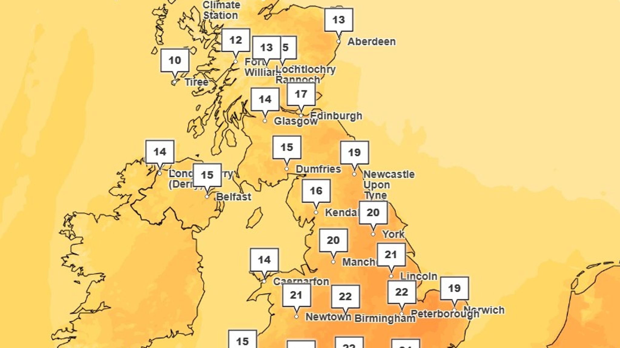
Starting Tuesday, temperatures across the UK are expected to climb to 22°C, offering a taste of summer warmth well ahead of schedule. The South East of England could see the mercury rise even further on Wednesday, with highs approaching 24°C. This level of heat is just one degree shy of the hottest early April temperatures ever recorded — 25°C, which occurred in both 2011 and 2020.
This consistent increase means the UK could witness the warmest day of the year so far not once, but potentially three times before the week ends. Such a rapid succession of record-breaking days is unusual for this early in the season, highlighting the dynamic nature of spring weather.
The Weather Shift: From Storm Dave to Warm Southern Winds
This heatwave follows closely on the heels of Storm Dave, which swept through northern England, Scotland, and Wales over the Easter weekend, unleashing destructive 70mph winds. The storm caused significant disruption and damage, but now the weather pattern is shifting dramatically.
A spokesperson from the Met Office explained the cause of this sudden warmth: “As Storm Dave has moved away, a high-pressure system is building behind it, dragging in warmer air from continental Europe.” This influx of southerly winds is responsible for the rapid temperature increase, a hallmark of spring’s volatility.
“It’s one of those seasons where weather conditions can change very quickly, day by day,” the spokesperson added. This explains why the UK is transitioning from stormy conditions to near-summer warmth in such a short period.
Why the Warmth Won’t Last and What Comes Next
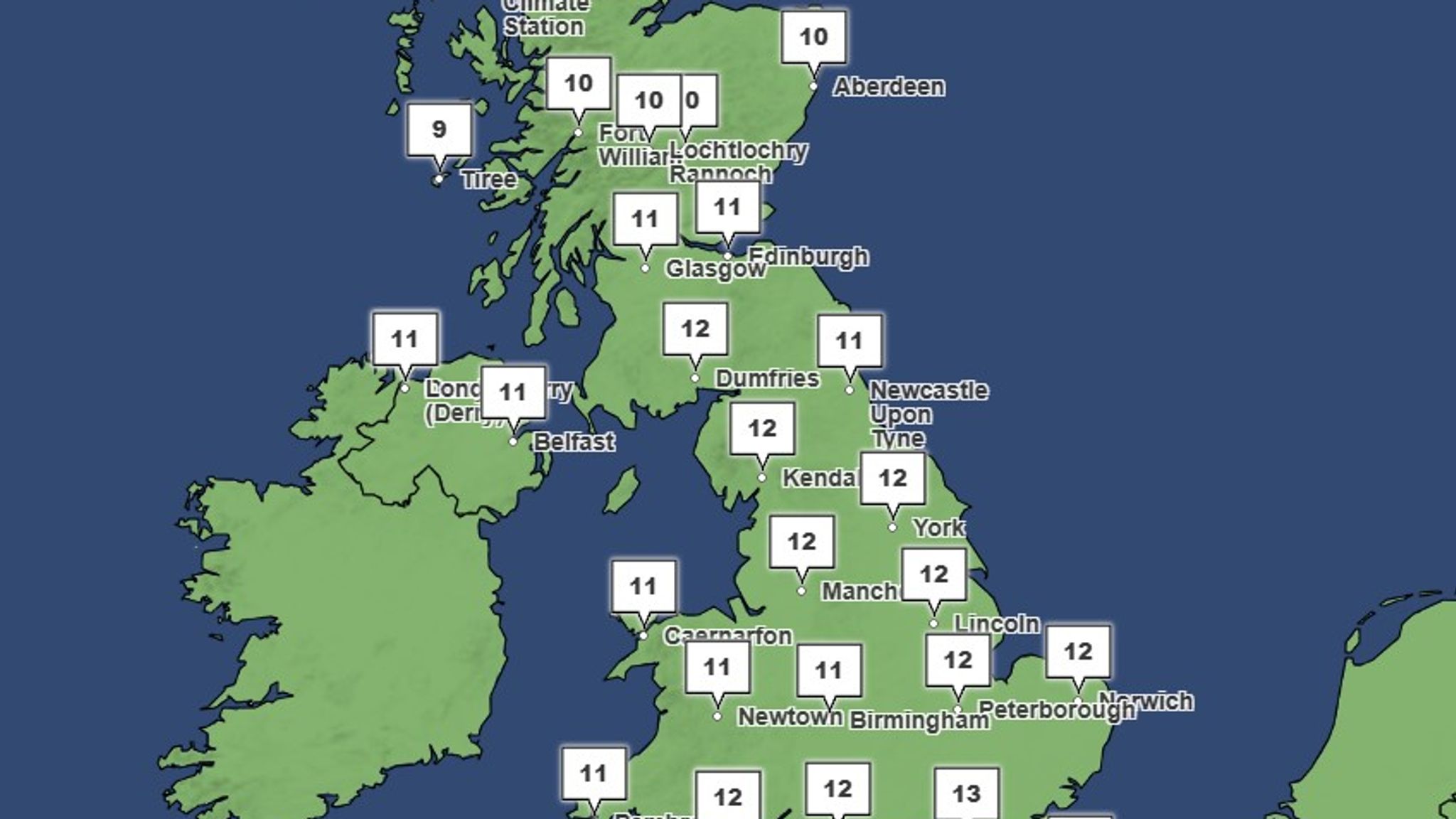
Despite the tempting warmth, the Met Office warns the heatwave will be short-lived. By Thursday, temperatures are expected to plunge sharply back to around 10°C, signaling a return to more typical early spring weather.
“The key factor is wind direction,” the Met Office representative said. “For the next couple of days, we’re seeing warm, southerly winds that push temperatures into the mid-20s. But as we head towards Thursday, the winds shift, bringing cooler air and more unsettled weather with rain and showers.”
This cooling trend will be especially noticeable by the weekend, with highs dropping to about 10°C in northern regions and around 14°C in the south.
Why This Matters: Early Heatwaves and Climate Trends
The early arrival of such warm conditions has caught the attention of meteorologists and the public alike. Early-season heatwaves can disrupt natural cycles, affecting agriculture, wildlife, and energy use. They also serve as indicators of shifting climate patterns, which make accurate forecasting increasingly crucial.
For residents and visitors across the UK, this week’s weather offers a brief but welcome glimpse of summer warmth. However, the quick turnaround also highlights the unpredictable nature of spring weather, reminding everyone to prepare for sudden changes.
As the UK enjoys these fleeting high temperatures, it’s clear that while warmth can bring comfort and outdoor opportunities, vigilance remains necessary for the cooler, wetter conditions that typically define this time of year.