UK Prepares for Unprecedented Heatwave with Records Set to Fall Repeatedly
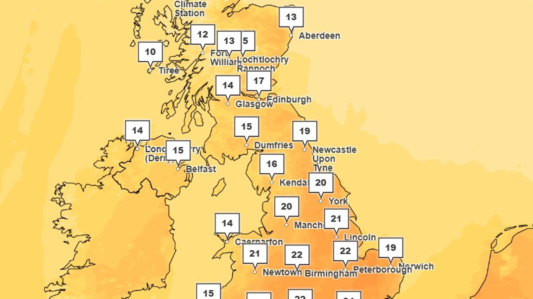
As spring unfolds, the United Kingdom faces an extraordinary meteorological event: a heatwave so intense it is expected to break the national record for the hottest day multiple times within a single week. Temperatures are forecast to climb unusually high for this time of year, with certain areas experiencing warmth typically reserved for summer months. Tuesday is predicted to see highs reaching 22°C, while by Wednesday, parts of South East England could endure soaring temperatures approaching 24°C. This rapid escalation signals a remarkable shift in the UK’s spring weather patterns.

What Is Driving This Early Spring Heat Surge?
Near-Record Temperatures Signal an Intense Early Heatwave
The anticipated temperatures for this week are not just warm, they are verging on historic. Meteorologists highlight that these readings will closely approach the highest early April temperatures ever recorded in the UK, which stand at 25°C, achieved in both 2011 and 2020. This suggests the UK is experiencing a heatwave that could be among the most intense for this season in over a decade. Experts have noted that the warmest temperatures of the year will be broken successively, potentially up to three times within a matter of days. Such a pattern underscores the volatility and extremity of current weather trends.
The Aftermath of Storm Dave and the Arrival of Warm Continental Air
This surge in temperatures follows closely on the heels of Storm Dave, a powerful weather system that swept across northern England, Scotland, and Wales during Easter. With gusts reaching 70 miles per hour, Storm Dave caused significant disruption and damage, leaving much of the region battered. As this storm system moved away, it created the conditions for a high-pressure system to take hold. This high pressure is now channeling warm air from continental Europe into the UK, dramatically raising temperatures.
A spokesperson from the Met Office elaborated on this dynamic, explaining, “As Storm Dave departs, a high-pressure system builds behind it, enabling warmer air to be drawn in from the continent. This time of year, the weather can change rapidly and dramatically, often from one day to the next.” This statement highlights the delicate interplay between weather systems that can result in sudden shifts from stormy to sunny conditions.
What Lies Ahead: The Temporary Nature of This Heatwave
Rapid Cooling Expected as Wind Directions Shift
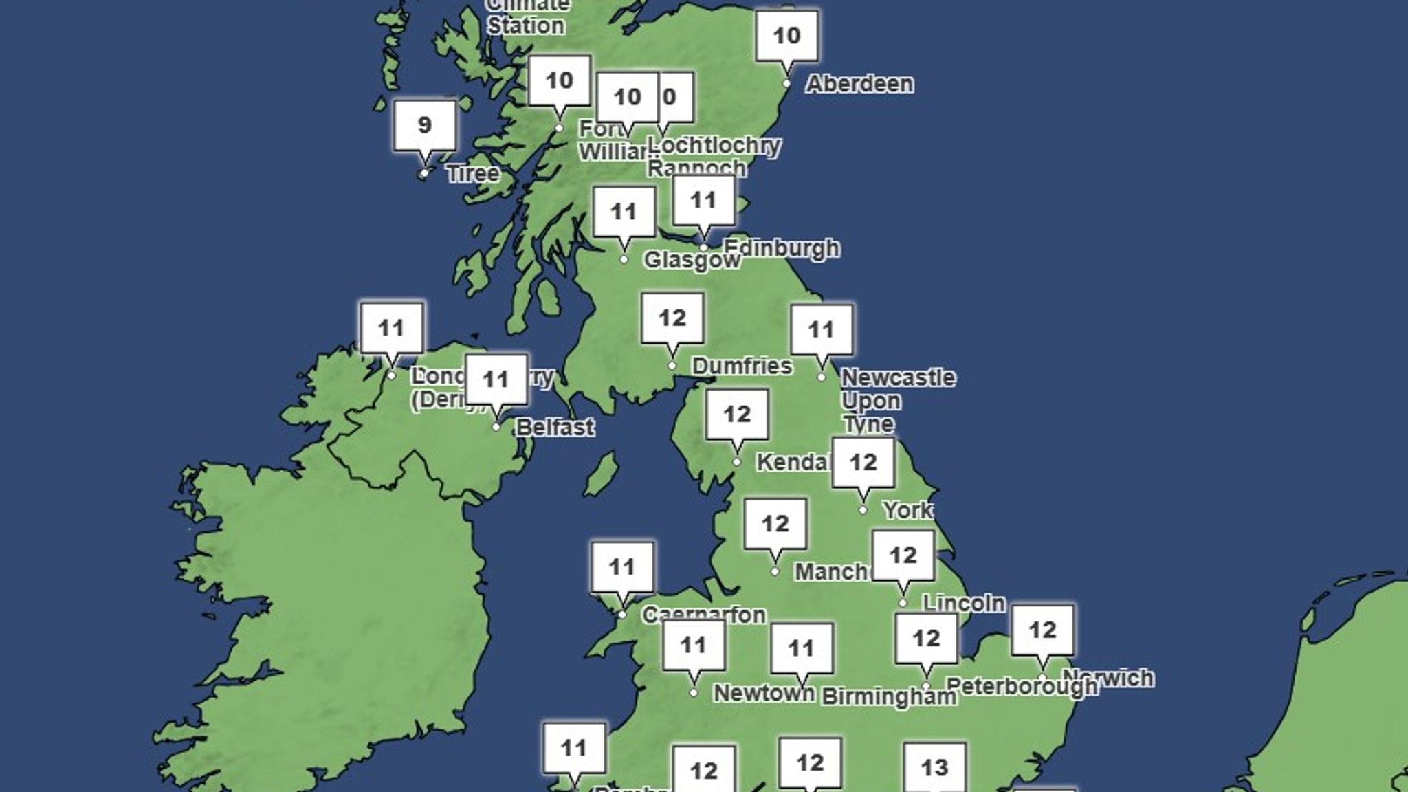
Despite the current blistering temperatures, meteorologists caution that this heatwave will be short-lived. By Thursday, temperatures are expected to fall sharply, dropping to around 10°C as wind patterns alter. The same Met Office spokesperson noted, “The direction of the wind plays a crucial role at this time of year. For a couple of days, southerly winds will drive temperatures into the mid-20s, but by Thursday, the situation will reverse. Cooler air will return, accompanied by rain and showers.”
This sudden temperature plunge serves as a reminder of the transient nature of spring weather in the UK, where warm spells can be quickly replaced by cooler, more unsettled conditions.
Weekend Weather: A Return to Cooler, More Typical Conditions
Looking further ahead, the weekend forecast indicates a marked return to cooler and more changeable conditions. Temperatures in northern regions are expected to hover around 10°C, while southern areas may see slightly warmer readings near 14°C. This shift will contrast sharply with the midweek highs and signals a reversion to the more traditional early spring climate.
The Met Office has noted that the early arrival of such intense warmth is unusual and represents a brief but intense heatwave. These fluctuations illustrate the complexity and variability of seasonal transitions in the UK’s temperate climate zone.
Why This Heatwave Matters
This unprecedented heatwave offers important insights into the evolving nature of the UK’s climate. Early-season temperature spikes challenge expectations and have implications for agriculture, public health, and energy consumption. Warm spells like this can disrupt natural cycles, affecting plant growth and wildlife behavior. For people, rapid changes in weather demand adaptability, particularly for vulnerable populations sensitive to heat.
Moreover, the pattern of successive record-breaking days emphasizes the increasing volatility of weather in the region, a trend that meteorologists continue to monitor closely. Understanding these shifts helps prepare communities and infrastructure for future climate variability.
As the UK navigates this extraordinary heatwave, the overarching takeaway is clear: while this surge in warmth is temporary, it serves as a vivid example of the dynamic and sometimes extreme nature of the country’s weather as it responds to broader atmospheric forces.


